The Valley of the devil, the elephant mountain, Mt. Kipipiri; sounds mysterious, right? Why those names? If only I could add emojis here to enunciate my excitement about the experience I am going to relay to you. Just imagine me making small rapid jumps with excitement. You won’t imagine why those places were given those names. Anyway 6:30 in the AM and Kamotho and Eli the African Explorer Magazine’s Travel guides , pick us up in the Nairobi CBD. We leave the city and the busyness that comes with it behind. We watch as the sites gradually transition from more buildings to more trees and bushes. An exhilarating experience as it pushes the childhood memories of the countryside from the subconscious to the conscious mind and floods my mind with all the nostalgia it could master. I want to bottle up my excitement because I’m around new people but does my mind let me? Noooo. “Edu, what is this place? I want land here” “Oh, this?…” That’s how the conversations start. The African Explorer magazine’s Travel guides turn out to be so knowledgeable about these areas that I don’t notice the 3-hour ride that brings us to the foot of Mt. Kipipiri.
Sign in, stretch stretch and we are off to my first hikeever; well, the first real hike.
The guides know to never let themselves be swayed by our excitement; we’d never make it to a quarter the distance of the mountain. Well, they don’t tell us that but I see them choosing a winding terrain that avoids taking the direct and steep climb. That’s not to mean that the climb was not challenging. That, it was. 15 minutes into it and I start dragging my beautiful delicate city feet. “Madam, what’s going on?” A fit one asks me. I try to prove that I’m also fit but, that was a lie and a big mistake. I eventually step aside and let her pass. But her chest was also heaving as she struggled to control her breath.
The guides are considerate enough and have several resting points. After each rest, it feels like you just started climbing. Your body is back in the game. At some point we find that the shrubs had grown on the footpaths while we were away on lockdown. The guide knows this is an exciting activity and allows us to create our way through the bushes. Oh, you should have seen this. The ladies you know were not so delicate. They tore their way through those bushes while laughing like it was just another stroke of a make-up brush on their face. A breathtaking sight.
We get to our second resting point and we start seeing all the other mountains of the Aberdare Ranges. We spot the Elephant mountain and it explains the name. It takes the shape of the back of an elephant and even has the ear. We see how the mountains seem to be crossing each other but never touching. At this point, the weather gets cold. It is when we get to our 4th stop that it decides we are never leaving without rain. If you didn’t have a rain coat, the other choice was to dance in the rain, and some of us did dance.
We got to my favorite place, a valley within the mountain, not the Valley of the devil yet. This valley has wild trees with all the shades and tints of green. They look as though nature chiseled them to take after a certain design. I can’t really put a finger on what the design was, but it was a beautiful alignment without losing all the scruffiness of the wild. Now to the Valley of the devil; that one was truly intimidating; we couldn’t climb down to it. But the waterfall in it, that was the sight. Looked like a long white satin fabric rolled down from the heavens and allowed to drape through a valley of green and brown. A sight.
I could never compress all the experience in here. But I reached the peak of the mountain. Was I tired? Very. In fact it took me two days to completely recover. Left room just enough for me to go through my daily routine. But I was proud of challenging my previous limits and having fun while at it. And the peak, it is made of the stuff you only see in the books and magazines and in those beautiful extreme sports in nature. It gave me an appetite for more adventures in the wild. Being tired and happy meant that we had truly done what is supposed to be done on a hike. I can officially declare myself a sportsperson and my sport of choice is hiking. (Flexes my non-existent bicep).
Yasuke was a retainer of African origin who served under the Sengoku Period Japanese daimyō Oda Nobunaga. In 1579 Yasuke arrived in Japan in the service of Italian Jesuit missionary Alessandro Valignano, Visitor of Missions in the Indies, in India. Before his passing Chadwick Bozeman was tapped to play the role of yasuke, thanks to Kings and General YouTube page, (link below), we can get to learn the story of this amazing man, the first African to don the dual swords, in a fun and captivating way!
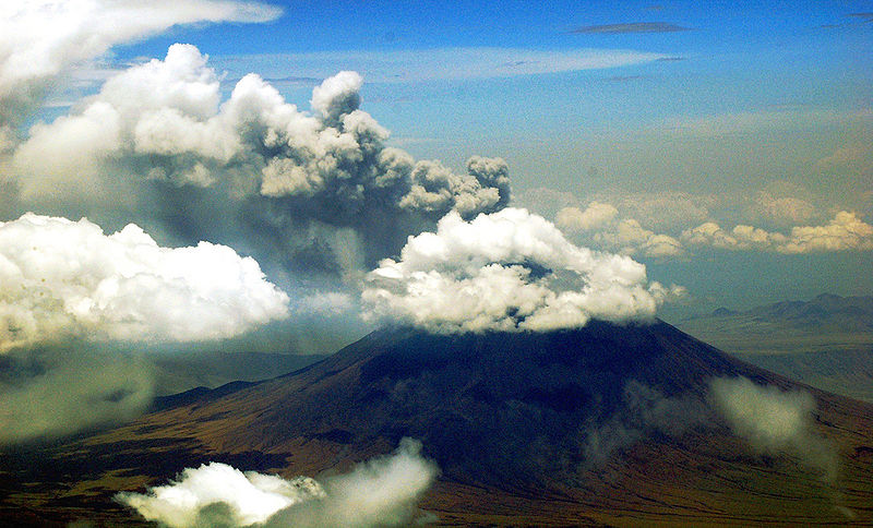
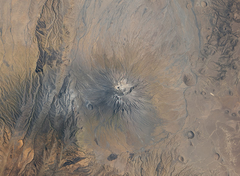
Ol Doinyo Lengai Volcano erupting mountain in Tanzania. Spectacular view from Cessna.
Ol Donyo Lengai is an active volcano located in the north of Tanzania and is part of the volcanic system of the East African Rift. It is located in the eastern Rift Valley south of both Lake Natron and Kenya. It is unique among active volcanoes in that it produces natrocarbonatite lava, a unique occurrence of volcanic carbonatite. Further, the temperature of its lava as it emerges is only around 510 °C (950 °F). A few older extinct carbonatite volcanoes are located nearby, including Homa Mountain.
The volcano has immense ecological, geological and cultural value. The Engaresero village located on the Western shores of Lake Natron, close to Ol Doinyo Lengai, has been chosen by the government of Tanzania to exemplify the Maasai pastoral system given its singularity, integrity, high diversity of habitats and biodiversity. The community has demonstrated a strong resilience in facing threats to their systems, and has maintained associated social and cultural institutions, which ensure its sustainability under prevailing environmental conditions.
Geology
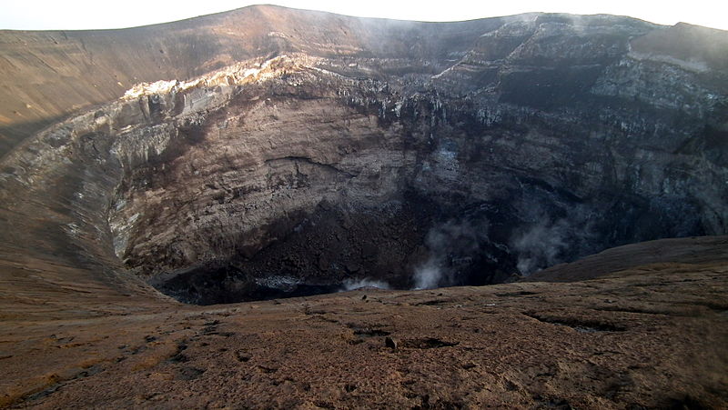
Crater of Ol Doinyo Lengai in January 2011, Tanzania , Albert Backer
“Ol Doinyo Lengai” means “The Mountain of God” in the Maasai language of the native people. The record of eruptions on the mountain dates to 1883, and flows were also recorded between 1904 and 1910 and again between 1913 and 1915. A major eruption took place in June 1917, which resulted in volcanic ash being deposited about 48 kilometres away. A similar eruption took place for several months in 1926 and between July and December 1940, resulting in the ash being deposited as far as Loliondo, which is 100 kilometres away. Several minor eruptions of lava were observed in 1954, 1955, 1958 the early 1960s. When Ol Doinyo Lengai erupted on August 14, 1966, two geologists — J. B. Dawson and G. C. Clark — who visited the crater a week later, reported seeing “a thick column of black ash” that rose for approximately three thousand feet above the volcano and drifted away northwards towards Lake Natron. When the two climbed the cone-shaped vent, they reported seeing a continuous discharge of gas and whitish-grey ash and dust from the centre of the pit. Volcanic activity in the mountain caused daily earth tremors in Kenya and Tanzania beginning on July 12, 2007. The latest to hit parts of Nairobi city was recorded on July 18, 2007 at 8.30pm (Kenyan Time). The strongest tremor measured 6.0 on the Richter scale. Geologists suspected that the sudden increase of tremors was indicative of the movement of magma through the Ol Doinyo Lengai. The volcano finally erupted on September 4, 2007, sending a plume of ash and steam at least 18 kilometers downwind and covering the north and west flanks in fresh lava flows. The eruption has continued intermittently into 2008, as of the end of February it was reported that the eruption appeared to be gathering strength, with a major outburst taking place on March 5. During April periods of inactivity have been followed by eruptions on April 8 and 17. Eruptive activity continued until late August 2008. A visit to the summit in September 2008 discovered that lava emission had resumed from two vents in the floor of the new crater. Visits to the crater in March/April 2009 showed that even this activity appears to have ceased.
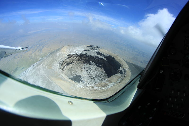
Flying over Oldoinyo Lengai. Taken with a fisheye photo looking toward the north-east ,Aaron Cawsey
Lava
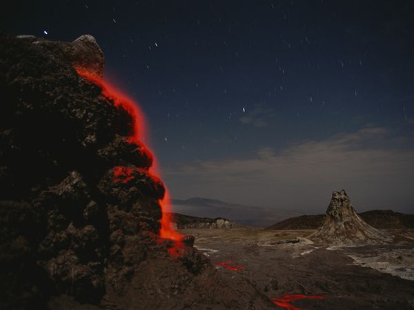
Whereas most lavas are rich in silicate minerals, the lava of Ol Donyo Lengai is a carbonatite. It is rich in the rare sodium and potassium carbonates, nyerereite and gregoryite. Due to this unusual composition, the lava erupts at relatively low temperatures of approximately 500-600 degrees Celsius. This temperature is so low that the molten lava appears black in sunlight, rather than having the red glow common to most lavas. It is also much more fluid than silicate lavas, often less viscous than water. The sodium and potassium carbonate minerals of the lavas formed by Ol Doinyo Lengai are unstable at the Earth’s surface and susceptible to rapid weathering, quickly turning from black to grey in color. The resulting volcanic landscape is different from any other in the world.
Video
Photo Gallery
After explosive eruptions, ash covers the surrounding landscape. The explosive eruptions built a cone over 100 meters high that enclosed a steep-walled crater. The new cone and crater are clearly visible in the centre of the image. The dark spot in the crater may be fresh lava erupted from a new volcanic vent. Gray ash covers the volcano and much of the surrounding landscape.
This article is from Geology Page. If you like Geology Check them out.
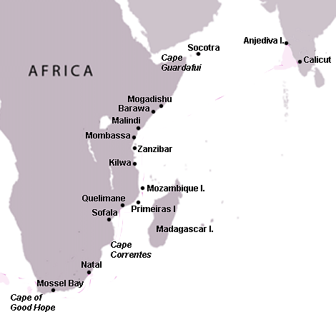
The Swahili Coast, located along the shores of East Africa, was a region where, from the 8th century CE, Africans and Arabs mixed to create a unique identity, often referred to as Swahili Culture. Swahili, which is also the name of this people’s language, means ‘people of the coast.’ Eventually, the entire coastal area blossomed into a number of important and independent trading cities which included Mombasa, Mogadishu, and Zanzibar. At their height from the 12th to 15th century CE, these city-states traded with African tribes as far afield as Zimbabwe as well as the period’s great trading nations across the Indian Ocean in Arabia, Persia, India, and China. The decline came in the 16th century CE with the arrival of the rapacious Portuguese who destroyed cities, built forts, and generally wrecked the finely balanced trade network they had come to gain advantage from.
Swahili
The term Swahili derives from the Arabic word sahil (‘coast’) and so means ‘people of the coast’. It not only refers to the coastal region of East Africa from Mogadishu in Somalia at its northern end to Kilwa in the south but also to the language spoken there, a form of the indigenous African language Bantu, which emerged in the middle of the 1st millennium CE. Later, many Arabic terms were mixed in and Swahili became the lingua franca of East Africa, even if different dialects did develop. The language is still spoken today in East Africa, continues to acquire foreign loan words, and is the national language of Kenya and Tanzania. The coast of East Africa provides many excellent natural harbours formed by submerged former river estuaries.
Ancient Settlement
The ancient peoples of what would become the Swahili Coast prospered thanks to agriculture and animal husbandry, aided by a regular annual rainfall and shallow coastal waters plentiful in seafood. Trade, conducted by dugout canoes and small sailing vessels, first began up and down this coast between the Bantu farming peoples living there in the first centuries of the 1st millennium CE during the region’s Iron Age. Sea travel was aided by the long lines of coral reefs which protect the shallow and calmer waters between them and the coastline as well as the presence of many coastal islands which provided both shelter and handy stopping off points en route. In addition, the coast of East Africa provides many excellent natural harbours formed by submerged former river estuaries.
Initially inhabiting the interior, Bantu people gradually moved in greater numbers to the coast as the second half of the 1st millennium CE wore on, creating over 400 new settlements and using stone – typically coral blocks held together with mortar – instead of or in addition to mud and wood for their homes. They profitably traded coastal commodities such as shell jewellery for agricultural products from the more fertile interior. When trade networks spread along the coast, so too ideas in art and architecture went with them, as did language, eventually spreading Swahili further afield to cover 1600 kilometres (1000 miles) of Africa’s coastline, making contacts with Madagascar, an island with an already long history of cross-cultural contacts, including with Indonesia.
Arrival of Muslim Traders
From the 7th century CE, the number of traders sailing the Indian Ocean greatly expanded and included those from the Red Sea (and so Cairo in Egypt), and then Arabia and the Persian Gulf. Arab dhows with their distinctive triangular sails filled the ports of the Swahili coast. Trade was even carried on across the Indian Ocean with India and Sri Lanka, as well as China and Southeast Asia. The long-distance sea voyages were made possible by the alternation of monsoon winds which blew to the northeast in the summer months and which reversed in the winter months. Indeed, sea travel was a lot easier and a lot faster than land travel at this time. As these helpful winds were lighter and less reliable the further south one went, so too the settlements became smaller and less frequent down the southern coast of Africa.
From the mid-8th century CE, Muslim traders from Arabia and Egypt began to permanently settle in towns and trading centres along the Swahili coast, especially on the safer coastal islands. In the 12th century CE settlers came from Persia, known as Shirazi people. The indigenous Bantu and all these foreigners mixed, as did their languages, with intermarrying being common and a consequent blending of cultural practices which led to the evolution of an entirely unique Swahili culture.
Medieval Trading Cities
The most important of over 35 major city-states along the Swahili Coast were (from north to south):
Mogadishu
Merca
Barawa (aka Brava)
Kismayu
Bur Gao (aka Shungwaya)
Ungwana
Malindi
Gedi
Mombassa
Pemba
Zanzibar
Mafia
Kilwa
Ibo
The Comoro Islands
Mozambique
The northern tip of Madagascar
These city-states, with the exception of Mogadishu, rarely exerted any form of wider political control beyond their immediate vicinity. Neither was there even very much cultural influence over the mainland interior. As many cities could not produce enough food, though, there must have been some arrangement with local tribes on the mainland who provided sorghum grain, rice, bananas, yams, coconuts, and more.
Trade
Goods which came to the Swahili city-states were collected from Africa’s interior, including southern Africa where Kilwa had a trade emporium, Sofala, near the kingdom of Great Zimbabwe (c. 1100 – c. 1550 CE). These goods could be consumed in the cities themselves, passed on to other African communities (after payment of duties to the cities’ rulers) or exported away from the continent by sea. In the other direction, goods came from Arabia, Persia, and India – and through these places, from China and Southeast Asia. Again, the foreign products were both consumed in the Swahili city-states and traded on to African settlements throughout East and southern Africa. Finally, Swahili city-states also manufactured goods for both their own residents and for trade such as pottery, cloth, and highly decorated siwa, the typical brass trumpet of the region.
Goods from Africa included:
Precious metals – gold, iron, and copper
Ivory
Cotton cloth
Pottery
Tortoise shells (principally to make combs)
Timber (especially mangrove poles)
Incense (e.g. frankincense and myrrh)
Spices
Rock crystal
Salt
Grain & Rice
Hardwoods (e.g. sandalwood and ebony)
Perfumes (e.g. ambergris which is derived from sperm whales)
Rhino horns
Animal hides (e.g. leopard skins)
Slaves
Goods imported from outside Africa included:
Ming porcelain
Pottery from Muslim states
Precious metal jewellery
Silk and other fine cloths
Glassware
Glass beads
Faience
Merchants exchanged these goods in a system of barter where one commodity was exchanged for another, but some of the larger cities like Kilwa were able to mint their own copper coinage from the 11th or 12th century CE. There were also commonly agreed upon currency commodities such as copper ingots or cowrie shells.
Government & Society
Swahili cities were independent from each other and usually governed by a single ruler, but details of how these were chosen are lacking besides some cases of one ruler nominating his successor. By the 12th century CE, the cities were ruled by the affluent Muslim merchant class. Assisting the single ruler or sultan were various officials such as a council of advisors and a judge, who were all likely selected from the most powerful merchant families. ‘The Muslim religion ultimately became one of the central elements of Swahili identity. To be a Swahili, in later centuries, meant to be a Muslim’ P. Curtin.
The social structure of the city-states generally had three levels. The ruling class – governors, merchants, craftworkers and holders of religious office – was composed of those with a mixed Arab and African ancestry. The second group was made up of slaves who were native Africans of unmixed ancestry and the third group was Arab and Persian traders who had not settled permanently.
Islam
Islam came to the coast with Arab traders in the 7th century CE, but the earliest known mosques, built of wood, are at Tanga, Kenya and date to the 9th century CE. Initially, some unorthodox Muslim settlers may have fled persecution in their homeland, but from the 12th century CE, the form of Islam most practised along the Swahili Coast was Sunni.
As the historian P. Curtin puts it: “The Muslim religion ultimately became one of the central elements of Swahili identity. To be a Swahili, in later centuries, meant to be a Muslim” (125). There were, though, differences in the practicalities of daily worship between Swahili Muslims and those elsewhere. For example, for many Muslim converts, the practice of appeasing spirits who brought illness and other misfortunes continued, as did the worship of ancestors, and in some places, women enjoyed better rights than they did under strictly sharia law. Swahili cities had cemeteries, and many tombs therein, besides having the unique commemoration of a single stone column, also contained precious goods along with the deceased, a very un-Islamic practice.
Architecture
Swahili mosques were smaller than elsewhere in the Muslim world and given very little decoration. With the exception of two 13th-century CE mosques at Mogadishu, Swahili Coast mosques do not have minarets and none have the inner courtyard typical of mosques elsewhere. One of the best surviving monuments on the Swahili coast is the Great Mosque at Kilwa. Constructed from coral rock blocks in the 14th century CE and added to in the subsequent century, the structure incorporated parts of an earlier mosque of the 10th-11th century CE. It has impressive monolithic coral columns which support a high vaulted ceiling, octagonal columns creating 30 arched bays, and a 4-metre (13 ft) square room with a domed roof.
Also at Kilwa are the ruins of a large palace, the Husuni Kubwa Palace (‘Large Fort’ in Swahili), built in the 1320-30s CE and located on a sandstone promontory. Covering almost 10,000 square metres (1 hectare), it includes a spacious audience hall, courtyard with tiered seating or steps, domed ceilings, storerooms (covering half of the palace’s area), and a pool. Although the architecture is similar to buildings seen in Aden with its domes, pavilions, and barrel vaults, the Kilwa architects added their own unique twist by embedding pieces of Chinese porcelain into the white lime plaster of the exterior walls for decorative effect. The palace, Great Mosque, and general attention to architecture at Kilwa led the Moroccan explorer and traveller Ibn Battuta (1304 – c. 1368 CE), who visited c. 1331 CE, to famously describe it as “one of the most beautiful towns in the world” (quoted in Spielvogel, 233).
Domestic housing along the Swahili Coast typically consisted of rectangular wattle-and-daub or mud-brick buildings with palm-leaf gabled roofs. Better housing, such as found at Kilwa, was made from stone and mostly of one storey. Swahili stone houses typically have two very long but narrow rooms (their width was limited by the length of mangrove poles needed to support the coral roofing) with few windows making their interiors dark but cool. There are smaller private chambers with many wall niches set at the back, there is often an inner courtyard with large windows and a toilet chamber and washrooms. Decoration was achieved by adding carved wooden window and door frames, window grilles, or even setting rows of porcelain bowls into the ceilings. Larger houses had well-watered gardens and orchards. Buildings were constructed very close together, often sharing a wall, and so cities often had very narrow and maze-like streets.
The Arrival of the Portuguese & Decline
The beginning of the end for the Swahili city-states was the arrival of one Vasco da Gama in 1498-9 CE. The Portuguese explorer had audaciously sailed around the Cape of Good Hope and up the east coast of Africa. Those who followed in his wake sought one thing: total control of the Indian Ocean trade network. With inferior weapons and a lack of cooperation between city-states, the Swahili Coast was not able to put up much of a defence.
The Portuguese had a large base at Goa, India, and they were hopeful of controlling both sides of the Indian Ocean. By building fortresses, notably at Sofala in 1505 CE, Mozambique Island in 1507 CE, and Shama in 1526 CE, they at least ensured they were in East Africa to stay. Unfortunately for everyone, the Europeans had no interest in establishing any mutually beneficial trade arrangements with the Swahili cities or interior African kingdoms, nor did they establish any form of administration. They merely wanted to extract everything and anything of value at as little cost as possible, preferably zero. Any rival traders were blown out of the water, their cities razed, and trade goods stolen.
The result of the Europeans’ rather short-sighted policy in East Africa, with additional contributing factors of their basic lack of manpower and corrupt incompetence, was that regional trade merely shifted northwards to avoid them. The Portuguese eventually responded by trying to grab the goods at the source, and one of these, noted for its gold, was the kingdom of Mutapa in modern Zimbabwe. Conquering the kingdom around 1633 CE, the Europeans were disappointed to discover there was not all that much gold about, certainly not in comparison to West Africa and Inca Peru. Tired of the terrible mortality rates caused by tropical diseases, they left northern and central East Africa to its own devices and concentrated on Mozambique, but not before causing such disruption that the heyday of the Swahili Coast was put to an end. Some city-states did, though, carry on trading into the 18th century CE under the control of the Omani Empire, becoming major exporters of slaves and ivory.
Mark Cartwright Mark is a history writer based in Italy. His special interests include pottery, architecture, world mythology and discovering the ideas that all civilizations share in common. He holds an MA in Political Philosophy and is the Publishing Director at AHE.
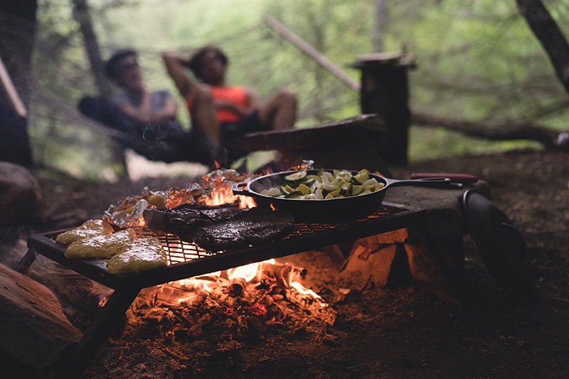
The allure of the great out doors draws many a wanderer to it. A night under canvas, stories by the camp fire, the freedom of sleeping outdoors is something that simply can’t be beaten, and it’s a great activity for families, friends, or even solo adventurers. Often the reason people haven’t tried camping yet is that they think they won’t enjoy it, or they don’t know what to expect, so we’ve reached out to some seasoned campers who know the ins and outs of every aspect, from years of experience.
New campers sometimes learn things the hard way, and even experienced campers overlook things from time to time. Remember these common mistakes of new campers, and learn how to become a smart camper with the best advice and tips for your first time camping.
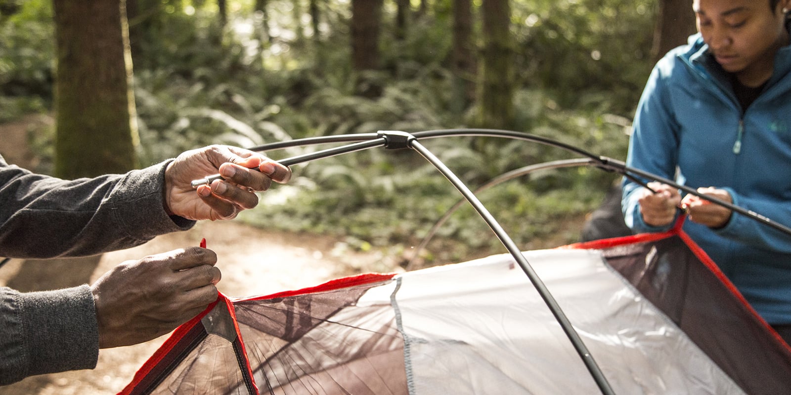
Become Familiar With Your Gear
New campers usually wait until they get to the campground before they try out new gear. It’s not uncommon to watch campers fumble for hours trying to figure out how to set up a tent. Practice really does make perfect. Set up tents in your backyard before taking them camping. Check the operation of lanterns and camp stoves to make sure they work properly. Try your sleeping bag one night on the living room floor to see how well you sleep in it. Be a smart camper, become familiar with your gear.
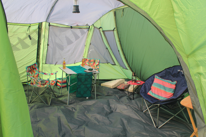
Buy a Tent That Is Big Enough
New campers frequently find themselves in a crowded tent. Make space and comfort a priority in your choice of tents (unless you’re backpacking). Most tents fit in a car trunk, so size and weight aren’t a major concern. For family camping get a tent with a capacity rated two higher than the number of campers that will use it. So for a family of two, get a 4-person tent, for a family of four a 6-person tent, and so on. Be a smart camper, buy a tent that is big enough.
Make (and Use) a Checklist
New campers often overlook a checklist. It’s no fun getting to the campground and finding out that you forgot something. Stay organized and make sure nothing is left behind by keeping a camping gear checklist. Use it while packing and check off each item. Update and revise the list as needed. If something breaks or wears out, replace it. If something really doesn’t get used, take it off the list. Be a smart camper, use a checklist.
Plan Your Meals
New campers don’t always put enough thought into meal planning. Figure out how many meals you’ll be making for how many people, and put together some menu ideas. Then do your grocery shopping a day or two before departure so that the food will be fresh. Avoid buying munchies. Don’t be one of those new campers that stops at the quick mart to buy food on the way to the campground. Be a smart camper, plan your meals.
Bring Sufficient Clothing
Camping is all about being prepared. New campers often neglect to bring enough clothes. Remember, there are no laundry facilities at the campground. Weather conditions can also demand different attire. You’ll like a rain suit in case it rains, a swimsuit for a dip, and maybe a sweater or jacket for those cool evenings. Be a smart camper, bring sufficient clothing.
Avoid Severe Weather
If you are a glutton for punishment, try putting up a tent in the rain. Camping is about relaxing outdoors, so don’t go camping if you know there is going to be foul weather. There is nothing more uncomfortable than sitting in your tent for two days while rain pounds your tent and the wind keeps laying it down on top of you. Right after a storm could be just as bad with rain-soaked campsites and mud. Be a smart camper, avoid severe weather.
Source material from: 10 Essential Tips for First Time Campers
BY DAVID SWEET


:max_bytes(150000):strip_icc():format(webp)/sunrise-camping--676019412-5b873a5a46e0fb0050f2b7e0.jpg)

:max_bytes(150000):strip_icc():format(webp)/camping-checklist-5a9f09308e1b6e0036960cf6.jpg)